
 By Nitin
Some places get into you. Nepal got into me.
Years ago I trekked in the Annapurna region, and what I remember most is not the peaks. It is the people. Teahouse owners who treated a stranger like family. Porters who carried more than I could lift and still smiled more than I did. I have written before that moving through that terrain, step by step, reset the way I think about everything else. It did. Nepal is one of the most beautiful places I have ever stood in, and its people are among the kindest I have ever met.
On the morning of August 26, in a valley north of Kathmandu that I have never walked but that looks like the valleys I have, a glacier let go. What followed took whole villages, took bridges, took a border crossing, and as I write this has taken at least 270 lives across Nepal and Tibet, with well over a thousand people still missing, many of them trekkers and travelers who went to those mountains for the same reason I did.2
It feels obscenely unfair. The people with the smallest carbon footprints I have ever seen, living in one of the most climate-punished landscapes on Earth, hit twice by the same river in fourteen months. I have been sitting with that unfairness for two days, and the only way I know how to sit with something is to try to understand it. So this essay is two things at once: a love letter, and an attempt at analysis. The professor in me needed to run the numbers. The person in me needed to write the last section.
the morning the mountain let go
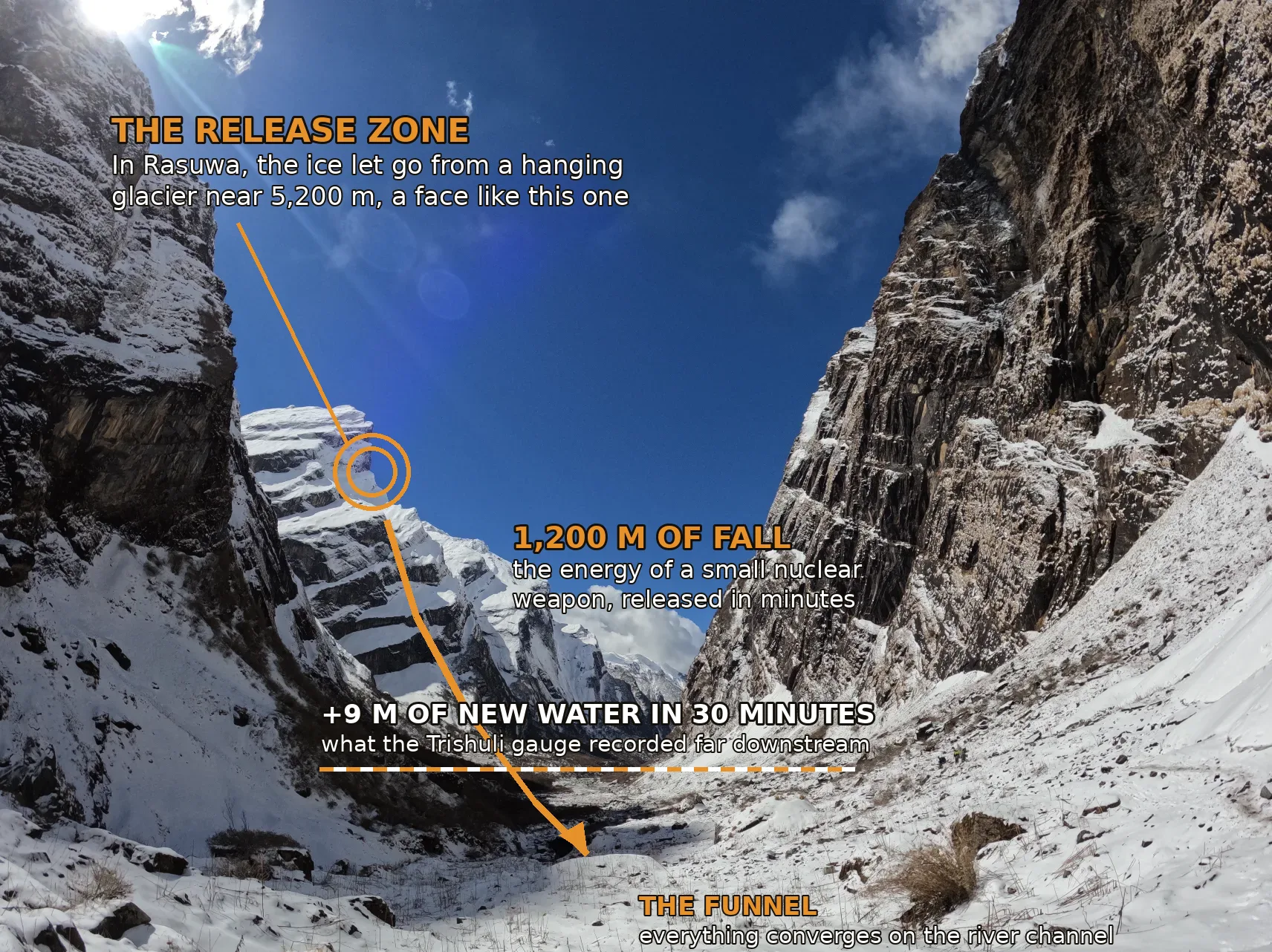
At 8:37 a.m. Nepal time, seismometers in the region recorded what was first logged as a magnitude 4.4 earthquake. It was not an earthquake. The signal, later assessed at magnitude 5.2, was the ground shaking because part of a glacier had detached high above the Lende Khola, the river that comes down from Tibet's Gyirong valley and becomes the Bhote Koshi and then the Trishuli as it enters Nepal's Rasuwa district.4 Scientists' current best reconstruction: the lower section of a hanging glacier, a mass of ice on the order of 600 meters across, broke off at about 5,200 meters elevation and fell roughly 1,200 meters onto the valley floor.3
There was no rain that morning. The district officer made a point of saying so.8 This matters more than it sounds, and I will come back to it, because almost every flood warning system on Earth begins with rain.
Within minutes, reports of flooding began coming down the valley.5 One survivor put it in a single sentence that I have not been able to shake: in half an hour, the flood came.1 Video from the corridor shows a churning front of gray slurry the height of a building consuming a town.9 The Miteri Bridge, the Friendship Bridge between Nepal and China at Rasuwagadhi, was destroyed. It had been rebuilt after the last flood destroyed it. That was July 2025, thirteen months earlier.5 Downstream, the surge damaged or halted more than ten hydropower projects, including the 111 megawatt Rasuwagadhi plant, Chilime, and Trishuli 3A.8 Far down the corridor, at Galchhi, a water gauge that stayed alive recorded the Trishuli rising nine meters in thirty minutes.6
Nine meters in thirty minutes. A three-story building of new river, assembled in the time it takes to drink tea.
Geologist Dan Shugar, who studies exactly these events, described the aftermath at the source bluntly: the bottom looks like a bomb exploded, just deposits from the broken-up glacier.3 He chose the right metaphor. The numbers say it was not much of an exaggeration.
the physics of a falling glacier
Here is the professor part. I want to estimate three things: how much energy the collapse released, where the water came from, and what the moving mass could do to anything in its path. All of it is order-of-magnitude arithmetic, the kind you can check on the back of an envelope, and I encourage you to check mine.
The energy. Comparable Himalayan and Tibetan ice-rock collapses have involved between ten and several tens of millions of cubic meters of material; the 2021 Chamoli disaster in India, the closest recent analog, mobilized roughly 27 million cubic meters.2 Take a range of 10 to 30 million cubic meters for Rasuwa, at roughly two tonnes per cubic meter for mixed rock and ice, falling 1,200 meters. Gravitational potential energy is mass times gravity times height. That works out to roughly 2 to 7 times 10 to the 14th joules.
The water. The strange thing about this disaster is that there was no lake. The July 2025 flood on this same river came from a supraglacial lake that had been quietly growing on a glacier at 5,150 meters until it reached about 638,000 square meters and let go.7 This time, analysts found no obvious lake in the imagery. So where did a river's worth of water come from? Landslide scientist Dave Petley's assessment is that it came from three places at once: ice converted to water by the energy of the collapse itself, water already sitting in the sediments the avalanche entrained on its way down, and the river that was already in the channel.4 Run the melt number: the collapse energy could melt on the order of one to two million cubic meters of ice even if only a fraction of it went to heat. An ice avalanche can manufacture its own flood. That is what makes these events so vicious. There is no reservoir to monitor, because the reservoir is created in the act of falling.
The force. What came down the valley was not water. Eyewitness video and every expert description agree it was a debris flow, water loaded with rock, ice, and mud to roughly twice the density of water. Hatim Sharif, a flood engineer, described it as moving like liquid concrete.2 The destructive pressure of a flow scales with density times velocity squared. That square is the whole story. Double the speed and you quadruple the force. Load the water with sediment and you nearly double it again.
Forty tonnes of force on every square meter. A bridge pier, a school wall, a teahouse: nothing built by people in these valleys is built for that, and it is not reasonable to expect it to be. For scale, the surge that reached Galchhi, far downstream and much slower, still implied a discharge of several thousand cubic meters per second, several times the river's normal monsoon flow, arriving essentially as a step function.
the race down the valley
Now the question that decides who lives: how fast did it move, and when did it arrive where? The honest answer is that we do not yet have measured arrival times for each village, and may never have precise ones. But debris flows of this type are well studied. At Chamoli in 2021, instruments and video showed the front moving at roughly 20 to 25 meters per second in the steep upper reaches and slowing as the valley opened. Using conservative speeds for Rasuwa, around 15 meters per second in the upper canyon and 8 to 10 lower down, and the reported geography, roughly 20 kilometers from the collapse to the border crossing, the timeline reconstructs like this.6
Sit with the middle of that chart. Fifty meters per second would be unimaginable; fifteen is terrifying enough. Fifteen meters per second is 54 kilometers per hour. Downhill through a boulder-choked canyon, that is faster than you can run, faster than most of these roads let you drive, and the river does not take switchbacks. The front outruns everything in the valley except light and sound. And this corridor is not empty wilderness. It is the trade artery to China and the gateway to the Langtang treks. On any August morning it holds farmers, traders, hydropower crews, border officials, and busloads of trekkers.
| Place | Distance | Time after collapse | What that time is enough for |
|---|---|---|---|
| Gyirong settlements | ~8 km | ~9 min | Drop everything and climb, if you already know |
| Rasuwagadhi | ~20 km | ~22 min | Evacuate a border post, with sirens and drills |
| Timure | ~23 km | ~27 min | Evacuate a village, with sirens and drills |
| Syabrubesi | ~37 km | ~50 min | Evacuate calmly, twice over |
| Betrawati | ~72 km | ~2 hr | Evacuate, then help your neighbors, then wait |
how much time is enough time
Here is the thing about that timeline that will not leave me alone. In these valleys, safety is almost always nearby. The villages sit on river flats, but the slopes rise immediately. For most people in most of these settlements, surviving this flood meant gaining thirty or forty vertical meters, a five to ten minute climb for a healthy adult, longer for the old, the very young, the sick. The physics question of survival reduces to brutal arithmetic: was the warning you received longer than the climb you needed to make?
Without any system, warning time is how far away you can hear a debris flow, which in a roaring gorge might be one or two minutes, sometimes less. The flood announces itself mostly by arriving. Now notice something painful in the seismic record: the collapse announced itself instantly. The falling glacier rang seismometers, including a station roughly 12 kilometers away, at 8:37, the moment it happened.6 The information that could have saved lives existed, in instruments, from minute zero. It just was not wired to anything that makes noise in a village.
This is the chart that answers the question people keep asking me this week, which is some version of: could anything have been done? Near the source, in the Gyirong valley, the honest answer is mostly no. Nine minutes minus detection and dissemination leaves almost nothing, and no responsible engineer should pretend otherwise. But from the border down, the answer is yes, and it is not a close call. Timure needed 27 minutes of warning to be a story about property damage. The information existed at minute zero, twelve kilometers away, in a seismometer.
should there have been cameras
So: should there have been cameras on that glacier, sensors in that gorge, sirens in those villages? Since this is the question I would ask if this were a systems review, let me treat it like one, steelman both sides, and then tell you where I land.
The case that warning systems could not have helped much. It is stronger than you might think, and it deserves to be stated fairly. First, this event defeated the entire standard architecture of flood warning. There was no rain, so rainfall-based forecasting was blind by design; as one expert put it, a flood with no rain defeats essentially every operational flood warning system in the world.2 There was no lake, so the lake-monitoring playbook, the one Nepal has actually used since it put sensors and sirens below Tsho Rolpa in the late 1990s, had nothing to watch. The reservoir manufactured itself during the fall. Second, the scale problem is real. The Himalaya holds thousands of glaciers and glacial lakes, and hanging ice that might collapse is far harder to shortlist than lakes that might burst. You cannot instrument everything, and a system that cries wolf gets ignored, which in some ways is worse than no system. Third, this valley is transboundary. The collapse happened in China; the dead are mostly in Nepal. A Nepali siren network is only as good as the data crossing that border, and as of this week Nepal's foreign minister was still trying to verify what, if anything, was communicated in those first minutes.5 Fourth, maintenance. A siren that has rusted quiet for five years is indistinguishable from no siren, and poor mountain districts are exactly where maintenance budgets go to die.
The case that this was preventable loss. Now the other side, and I will tell you up front that I find it overwhelming. This was not an unforeseeable event in an unwatched valley. The same river produced a deadly transboundary flood in July 2025, thirteen months earlier. That flood also came with no warning, at 3:15 in the morning, from lakes that were not being actively monitored. It killed eleven people, destroyed this same bridge, and knocked out around 250 megawatts, roughly 8% of Nepal's power supply.7 After it, researchers published exactly the recommendations you would hope for: monitor the ice upstream, share data across the border, build early warning. China reportedly committed to a site-based warning system. Nepal and China discussed real-time data sharing in May. No formal agreement was signed.5 Fourteen months of warning, and the valley met the second flood the way it met the first: with nothing between the ice and the villages but gravity and luck.
And the technology asked for here is not exotic. The event was self-announcing: it rang a seismometer 12 kilometers away at the moment of release. A detection tripwire for this valley is a solved problem in engineering terms: seismic stations that flag a collapse signature, one or two hardened water-level sensors in the upper gorge as confirmation, an automated trigger, sirens in every riverside settlement, and drills so people know that the sound means climb, now. Solar powered, satellite linked, redundant. Nepal has run versions of this below Tsho Rolpa for a quarter century, and hydropower operators on other Himalayan rivers have used gauge-triggered sirens to buy their crews minutes. The whole corridor could be wired for less than the cost of rebuilding the Miteri Bridge once, never mind twice, never mind 250 megawatts, never mind a single school of children.
The mountain gave us the data at minute zero. We had simply never asked the mountain to speak to a siren.
So where do I land? Cameras alone, no. A camera is a way to watch a disaster happen in higher resolution. What this valley needed, and still needs, is the tripwire: detection wired to noise. It would have saved few people in the first nine minutes of valley, and I will not pretend otherwise, because false comfort is its own kind of lie. But Timure had 27 minutes. Syabrubesi had nearly an hour. Betrawati had two. Against a five to ten minute climb to safety, that is not a marginal improvement. That is most of the death toll on the Nepali side of the border, alive.
The uncomfortable truth is that this is not a physics failure or even mainly a money failure. It is an institutional failure, the kind I recognize from a much lower-stakes life in technology: the risk was known, the fix was understood, the pilot precedent existed, and the work fell between two owners. Between two countries, in this case, with a river that does not care about the border it crosses. After the 2025 flood, this specific valley was arguably the single most obvious candidate for a warning system in the entire Himalaya. The second flood was not unforeseeable. It was unforeseen by choice, the accumulating kind of choice that consists of meetings held and agreements not signed.
I want to be careful here, because grief looks for villains and I do not think there is a villain. There are two governments with limited budgets, a scientific community that saw this coming in general but cannot yet see it coming in particular, and thousands of valleys that all have a claim to the same scarce sensors. But the 2025 flood moved this valley out of the general and into the particular. That is what a warning shot is. The unfairness I started this essay with is mostly nature's. This part is ours.
what i am left with
I keep thinking about the trails. When you trek in Nepal you spend day after day walking beside these rivers, on paths cut into the sides of exactly these funnels. You cross the suspension bridges with the prayer flags. You sleep in villages built on the flats because the flats are the only flat ground there is. The geometry that makes those valleys the most beautiful places I have ever walked is the same geometry that makes them deadly. I did not understand, standing on that valley floor in Annapurna years ago, that I was standing in the barrel of a gun that fires once a century. The people who live there understand it completely, and they stay, because it is home, and because home in the mountains has always meant living on the river's terms.
The tolls will keep changing after I publish this, so I will not pretend precision: hundreds are dead across both sides of the border, and more than a thousand people were still unaccounted for as I wrote, among them trekkers from a dozen countries whose families are refreshing news pages in a dozen time zones tonight.2 Whole families in Rasuwa are gone. Border guards, hydropower workers, teahouse owners, the people who wave you up the trail. Some of the people lost in that corridor were surely the kind of people who once handed a tired stranger like me a cup of tea without being asked.
Nature is not cruel. Cruelty requires intent, and a glacier has none. But standing in the path of that indifference, feeling how little it weighs your goodness, your plans, your children, that is the most frightening thing I know. Physics does not negotiate. Nine meters in thirty minutes does not pause because the people in its path are kind. That is what makes it so scary, and that is exactly why the parts we can control, the sensors, the sirens, the agreements, the drills, are not bureaucratic details. They are the only vote we get.
So this ends the only way it can. For the people of Rasuwa and Gyirong, for the ones who were lost, for the ones still waiting at the edge of a broken road for news of someone they love, for the ones who survived and now have to rebuild a life the river took twice in fourteen months: I am praying for you. For the rescuers working a valley that is still dangerous, I am praying for you too. And for the rest of us, the prayer that actually costs something: that we let this be the last flood that finds those villages silent. The mountains will let go again. That part is certain. What we do with the minutes in between is the only part that was ever ours.
References
- NPR: Dozens killed, hundreds missing as avalanche-triggered flash floods hit Nepal and China (August 26, 2026)
- Al Jazeera: Nepal-Tibet floods, what is a glacial collapse and how common is it?
- Scientific American: Wall of floodwater sweeps away villages in Nepal
- EarthSky: Nepal flash flood nightmare, what caused it? (seismic record and Dave Petley's analysis)
- The Kathmandu Post: Nepal seeks answers on flash flood as India, China, US and World Bank offer support
- ICIMOD: Major flash flood sweeps through Nepal's Rasuwa district (Galchhi and Malekhu gauge data, seismic stations)
- Stimson Center: Investigating an emerging climate hazard, transboundary glacial floods on the China-Nepal border (the July 2025 flood)
- Everest Chronicle: Catastrophic flood in Rasuwa (hydropower damage, no rainfall at district headquarters)
- Newsweek: Video shows wall of water consuming a town in Nepal
- Copernicus Emergency Management Service: EMSR927 rapid mapping activation for the Nepal flood